Reminder:
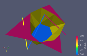
AthosGEO View is for the visualization of geological (underground) data. It is freely available with a permissive open source license, taken from ParaView (https://paraview.org). The focus is on the 3d display of block models and sampling data (samples, drillholes). The underlying ParaView allows the additional display of topography, animations, annotation and much more.
AthosGEO Blend is specialized for the production of cement raw material. It includes all the functionality of AthosGEO View and adds tailor made fonctionality for optimizing the production of a raw mix with predefined quality. This includes options to use external addititves and produce several products simultaneously. Once a planning is done with AthosGEO Blend, the results can also be visualized with AthosGEO View.
For more details about the different variants see here for example.
What's new? Short version
This is a short list of new features for the quick reader - more detailed descriptions will be given below:
- Optimizer batch runs with AthosGEO Blend, including chart generation
- Improved Scheduler fine tuning: selectively forcing blocks (AthosGEO Blend)
These are the most important improvements, and both are for the users of AthosGEO Blend only. But also the users of the free AthosGEO View variant will see some new goodies like:
- Improvements of the Athos Table View, more direct box chart generation and manipulation of attributes for triangulated topo surfaces
- Improvements that are inherited from ParaView: The new version is based on version 5.10.1, not any more 5.9.1. This affects the Find Data dialog and the Python Editor
AthosGEO Blend: Automatic series of Optimizer runs
The Optimizer module calculates the theoretical maximum quantity of raw mix that can be generated from a specific rock volume, represented by a block model and delimited by a mining license, a maximum final pit angle, maximum depth etc. The specification of the raw mix is given by quality (chemical) constraint ranges. It is possible to include additional materials from external sources - correctives or alternative raw materials - and specify minimum and/or maximum limits for them. Also a second or further product can be specified, like a certain quantity of hight grade limestone besides the clinker raw material. All this is not yet a mining plan, but it provides a background for understanding the potential of a given quarry for a specific product: What are the quality characteristics of this quarry? Which would be the optimum set of additional materials in order to achieve the maximum quantity of raw mix from it?
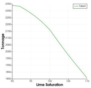
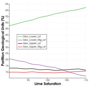
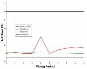
Often a next question follows immediately: How does the maximum achievable tonnage change if some of the input constraints are changing? What if we require a higher lime saturation? Or if we want to add some contaminated soil to the raw material? No problem: Just change the constraints and re-run the Optimizer! However, this is getting tedious if an entire sequence of constraints should be calculated, e.g. for preparing a chart. This not the least because already a single optimizer calculation may take it's time, if the model is not very small or if more than one product is required.
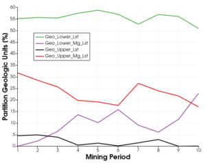
This is where the new batch optimization feature comes into the game. It allows to run an entire series of optimizations as a batch, while the user can do something else or go for a coffee... With the aid of extractors (available since AthosGEO 2.1.0), the results of every optimizer run are written into series of output files, for further processing. Technically, running such a batch means to run an animation with AthosGEO Blend: Users of the Scheduler module already know how this is is done.
Once we have all these output data files, we extract relevant results with another new filter which allows to display them in another summary table or generate a chart - because often a graphic says more than 1000 words or endless tables.
Side Effect: More easy charts from Scheduler runs
With the aid of the above mentioned extractors, series of result tables can also be generated from Scheduler runs. And with the aid of the new data collection filter, again interesting results can be collected and represented as summary tables or charts. This comes as a welcome side effect of the above new developments.
AthosGEO Blend: Finetuning Scheduler operation: the new Force attribute
The Scheduler simulates mining operation in periods which are typically years: The user specifies Start blocks for starting the simulation, and the program will try to extract as many full mining periods as possible, always maintaining the specified quality and mix constraints (see above). This may be good enough if the purpose is proving the feasibility of a certain number of periods. It is not sufficient if a more detailed planning for the next 1..2..3.. years is required. In such a case, the user needs to specify additional mining constraints and preferences in order to achieve an acceptable result:
- Preferred directions: For each block it can be specified in which direction to proceed first - if quality constraints do allow.
- Maximum mining angle: A maximum working slope angle can be defined for each block and for the four main directions.
Sometimes it is required to specify even more explicitly which blocks should be taken and which not - and this was so far not entirely possible:
- Exclucing blocks explicitly can be achieved with a synthetic attribute plus a block constraint.
- Including blocks explicitly was so far not possible! But with the new Force standard attribute it can be done:
- Assign a value of 1 to a block and this block will have to be consumed within mining period 1, etc.
Of course in general terms, explicitly forcing or excluding blocks is against the idea to let the software decide what the optimum would be, but in certain cases additional technical mining criteria may have to override the quality driven optimization.
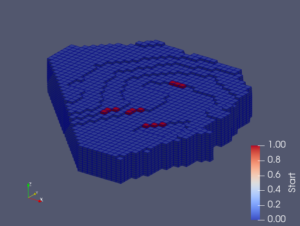
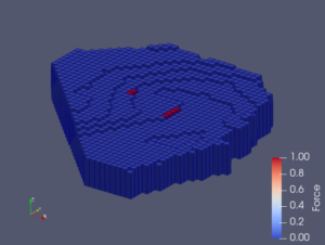
As can be seen in the above example, Force blocks are automatically treated like they were Start blocks at the same time.
AthosGEO Blend and View: Handling of the "Nb" attribute
This is a performance improvement for users of AthosGEO Blend and the Scheduler module. The explanation has to be a bit more technical, so if you are not interested, just skip this section. Users of AthosGEO View will benefit as well: The do not any more need the Nb attribute at all! So far it was required for the proper operation of the Merge blocks vertically filter.
Technically, block models are unstructured grids in the terminology of ParaView, consisting of hexahedron cells representing the blocks. That means they can be arranged in absolutely any way (size, position, orientation etc.) in principle. However, for proper operation of the Scheduler module, certain constraints apply:
- A block model can consist of several disjoint model parts (e.g. different quarries). Within one such part, block dimensions in x and y as well as the rotation angles (round z axis) have to be homogeneous.
- In z direction, block dimensions can be varying, and they do not need to match between neighbor blocks. This in order to match varying mining bench heights, even if the benches are not entirely horizontal because they are following slightly inclined geological units.
Now the Scheduler must be able to find neighbor blocks quickly and easily, for different reasons. However, the existing ParaView functionalities for that purpose do not work properly because they rely on common points between neighbor blocks - which do not necessarily exist according to the above specification. This is the reason for introducing the Nb attribute: It is calculated once and explicitly tells which are the neighbor blocks of a specific block in all 6 main directions in space.
The problem is: So far this calculation is very time consuming. With the new version it was now possible to implement a new algorithm for that purpose that takes much more into account the above characteristics of an AthosGEO block model. The effect is impressive: We are now talking about seconds, while before it could be 10min or half an hour for a larger model.
For users of AthosGEO View, the Nb attribute is not any more required for the Merge blocks vertically filter: According to the above specifications, vertical neighbor blocks always have 4 common points, so the ParaView functionality can be used instead.
AthosGEO View and Blend: Column order in tables
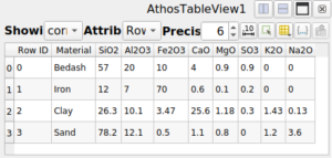 ParaView displays tables in the Spreadsheet View, where columns are always appearing in alphabetical order. AthosGEO has also the Athos Table View: The only difference is that columns are always ordered in a way that is much more adequate for the purpose of block model and sample data display, respecting also naming conventions of AthosGEO. Two improvements have been added to this with the new version:
- So far, automatic display of tables in an Athos Table View only happened if the table was the output of an AthosGEO provided function (filter). If the table was read from a CSV file, it was always shown in a Spreadsheet View first, and switching to an Athos Table View was an additional step. Now the user has a choice already with the readers: either CSV Reader or CSV Reader for Athos Table View.
- Another shortcoming is now removed: So far, exporting a table with all it's display settings into a CSV file did not maintain the Athos Table View column ordering: Columns appeared in alphabetical order in the output. This has now changed: Column order in the CSV file is the same as in the view, so it appears also in external tools such as Excel or other.
AthosGEO View and Blend: Writing/changing attributes for triangulated surfaces
With Write value and Write multiple values the user is able to do simple data manipulations in block models or sampling sets (thus technically: unstructured grids). This despite of the fact that neither ParaView nor AthosGEO are designed to be model editors.
However, also triangulated surfaces (or many other geometries like lines or points) are technically made up of points and cells (although being of type poly data and not unstructured grids), so it was possible to extend the same functionality also to them. One possible application is to assign different colors to different triangles in a triangulation explicitly, or to single line segments.
AthosGEO View and Blend: Box charts
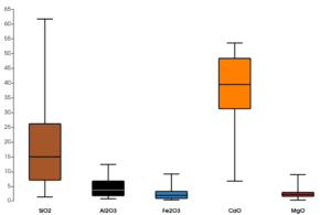
Another little update applies to box chart generation. This is done with the Compute Quartiles filter. However, by default this filter considers only point attributes, while the quality attributes in block models and sampling sets are stored as cell attributes. This has been changed now for AthosGEO.
AthosGEO View and Blend: Write point and line data into DXF files
DXF files are not supported by ParaView: This is an open source software, and DXF is not an open data format. Certain features are documented, others not, and permanently new ones are added without much consideration for backwards compatibility. In other words: Supporting DXF files for pragmatic reasons is always a compromise to some degree, and going for old versions of that format is always a good idea if such files should be imported into AthosGEO.
DXF writers are less of a problem: They can simply go for some old and well proven version of DXF. In this sense, the already existing export of triangulated surfaces to DXF files is now extended to supporting also points and lines.
Improvements inherited from ParaView
With the update from AthosGEO 2.1.0 to 2.2.0, the underlying version of ParaView was updated from 5.9.1 to 5.10.1, inheriting all improvements of that new version. Some are interesting also for users of AthosGEO:
- Extractors were already a new feature in version 5.9.1, but together with the above new batch optimization feature they are becoming much more interesting.
- The Find Data dialog is now replaced by a dockable panel.
- The Python Editor has seen some improvements.
- An important bug fix: It is now possible to read and write file names including so called special characters, i.e. characters outside of the basic ASCII character set: accent aigu, umlaut etc. This problem is now mostly fixed: Unlike in previous versions, files can always be written and read. Only one thing is not fully functional yet: generating folder names with special characters from inside AthosGEO is still buggy. Working with existing such folders is no problem.
Final words
We hope that the provided updates and fixes are delivering a lot of added value for all customers: Please go ahead, download the new version, install and use it. If you hesitate, because of potential compatibility or other issues, or if you simply do not want to "change a winning team", please do it anyway! Because there is no relevant risk: Updating is like installing a new software, so you will keep the old version together with the new one, and only once you fully trust the new version you will remove the old one.
Last but not least we want to say thank you to the paying customers of AthosGEO Blend: Without their support, further development, update and support would not be possible! Even though the most important current updates are for the benefit of Optimizer and Scheduler users, they are also for AthosGEO View an important step forward. Comments, suggestions and also bug reports are always very welcome: Please feel free to contact us.