
The new 2.1.0 is now a gradual improvement of the AthosGEO software, adding new features to all variants and modules. The most important ones will be described below in the more technical sections.
At this point it must be emphasized that further development also in 2022 and on will largely be guided by user feedback. So please feel free to think about it and send me your proposals: They are always welcome and will be considered as much as technically possible. This is a good way how you can contribute to the further evolution of the tools.
One more thing to emphasize: Please go ahead and download the new version, install and use it! Even though there is no guarantee that no bugs have crept into the new release we want to encourage everybody to do this step: Bugs will only go away if somebody finds and reports them. Meaning that the installation and use of a new release version is also a contribution to the further progress - and this is not meant to be a cheap excuse for not seriously debugging the software in the first place! There are simply too many possible ways to use the software to find everything during "dry runs".
If the latter sounds a bit scary, if you feel like you have better things to do than trying new versions as long as you have one running that serves you well: There is always the option to do both at the same time! Because installing a new version of AthosGEO (View or Blend) does not mean that you will lose the old one. In other words, version updates are not handled like updates, but rather like installing a completely new software (which is btw. also true for ParaView). An existing activation (AthosGEO Blend) will still be recognized automatically: You will have then two versions of the same software, both running with the same license and activation. Only once you feel fully comfortable with the new relase, you can decide to do a cleanup and remove the old version from your computer.
In other words: There is little to fear when installing a brand new version because at any moment a fallback version is still available. Only drawback: working with new features will of course not work with the old one, and sometimes state files are not fully compatible between ParaView and AthosGEO versions, for the same reason.
If you are not interested in more technical details about the new release, this is the moment to stop reading! Otherwise you are invited to go ahead.
ParaView
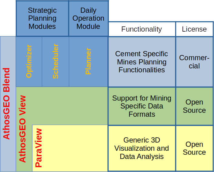
As can be seen from the chart above, ParaView is the base of both variants of AthosGEO, and also ParaView is actively being further developed. With AthosGEO version 2.1.0, the step was done from ParaView version 5.8.0 to version 5.9.1, including a number of little changes and new features that are immediately inherited by AthosGEO. We are not going into details about these updates here: please have a look into the release note directly here for version 5.9.0 and a little more here regarding mostly bug fixes that went into version 5.9.1.
Looking into the main ParaView website here, you will find out that at this time version 5.10.0 is out already, since two months actually. Again there are interesting new updates and features (as can be seen here). For AthosGEO this will be for another new version in the future.
AthosGEO View
Documentation
So far, AthosGEO software included short explanations of all the filters, but no coherent manual by functionalities and work flows. Such a manual exists since the summer of 2021, as announced and published with the previous blog post. Now, with version 2.1.0, the manual is directly accessible from the Help menu and extended to include the new AthosGEO View functionalities. It exists both in HTML and PDF format, for online use or as a printed handbook.
The manual covers only AthosGEO View functionalities, which is: visualization of geo data in many powerful ways. That does not mean it is not equally useful for users of AthosGEO Blend: Visualization of both the initial deposit as well as of the planning results, which is a not unimportant step during a planning process.
Clip topo surface by geometry
Clipping and cutting both block models and topo surfaces is supported by a number of filters. ParaView offers some, with options to either cut every single cell (which means blocks in the case of block models and triangles in the case of topo surfaces) or leave them unaffected. AthosGEO View adds functionality to handle attributes in a way that is consistent with the AthosGEO attribute naming conventions. A new filter is now added that has a focus on more precise geometric topo surface clipping. The purpose is to better support updating the topo after removing blocks from a block model after some mining progress: One filter allows to generate an overall outline of a set of blocks, like those being extracted, and another one allows to use this outline to be used like a cookie cutter for cutting a topo surface.
Have a look into the manual section about clipping and cutting here for a more detailed description.
Merge by category
If a block model is used as a base for quarry planning, it is best if the blocks are following the intended bench design of the mining operation. This is not a problem if that design is regular, with a fixed bench height and all benches perfectly horizontal. However, if benches are slightly inclined and/or having variable heights, e.g. with the intention to follow geological units, this is not any more supported by common available block modelling (geostatistics) tools, so it has to be achieved in two steps:
- First calculate a model with very flat blocks, like 1m or 2m,
- then merge blocks vertically according to the intended bench design.
The new filter will do the second step if the intended benches are previously marked with category values.
Show attribute types
For the operation of AthosGEO, the concept of attribute types is very important as soon as any calculations are done based on a block model: tonnages need to be added, quality attributes averaged, indices and coordinates ignored - just to give a few examples: more details about the subject can be found in the manual section about attribute conventions here. These attribute types cannot be freely assigned. They are automatically determined based on the attribute names - and sometimes it is not obvious at first sight whether an attribute name would be this or that type. A new filter is now doing only this: It takes a block model or other item as input and generates a list of all attribute names, together with their attribute types and value ranges.
AthosGEO Blend - Optimizer and Scheduler modules
From this point, users of AthosGEO View can stop reading because the following new features will not be understandable without some knowledge about the operations of the Optimizer, Scheduler and Planner modules.
Improved Remove taken and wasted filter
This filter allows to automatically remove taken tonnage after some mining period(s), updating tonnage attributes and removing blocks that are completely consumed. So far it did not care about pit or zone type attributes, and this is also not easily feasible in an unambiguous way: If e.g. a pit attribute indicates that a block is only 70% within that respective pit, and if now 20% of the tonnage are removed: Are these 20% going away from the part of the block that is within the pit? Fully, partially or not at all? The problem is that a model can have several pit attributes, maybe for different mining variants, and only if we know that a certain pit attribute was also being used for the calculation of taken tonnage we are sure that tonnage must have been taken from the part of the block that is inside the pit. With the current update, the user is able to indicate one pit or zone attribute where this assumption can be made.
Prevent automatic downward mining
This is about a new option for the Scheduler module that is already part of the very last pre-v2.1.0 intermediate releases. It turned out that the Scheduler's proposed mining progress was sometimes going downwards, i.e. to lower benches or levels even though there would have been ways to continue mining on the already opened benches. To some degree this can be avoided with the use of preferences, but if the user wanted to have full control about opening new benches, this could not easily be achieved. Now there is a new option available that simply disallows going downwards to another bench, so once the user intends to do that step, Start blocks need to be specified accordingly.
Define and use a Force attribute
Another new feature for finetuning the operations of the Scheduler, in other ways also potentially useful for the Optimizer module, is the possibility to force specific blocks into the taken product tonnage. Like the user has to mark blocks as Start blocks, indicating possible opening points for a planning sequence, he can now mark blocks as Force blocks in order to make them part of the output no matter what. This will be treated as a hard condition for the production, unlike working with preferences that are only followed as long as the quality criteria are met. As forcing is contradictory to optimizing, it is quite possible that the total achievable tonnage will be reduced by the use of this option. This can go up to the point that mining is entirely blocked because the forced blocks simply do not fit into the target quality constraints, so used this function with care!
So the function was not introduced for daily use and overriding the optimization, but because in certain cases it allows for just the amount of finetuning that makes an almost good planning perfect.
AthosGEO Blend - Planner module
Planner function to remove unused samples and blasts
The Planner module is for the daily operation planning: based on blasthole samples, it calculates average blast pile compositions, and from a set of offered blast piles, it generates load and haul plans. All the entered data are collected in a database, together with all the performed operations. Later on, this database can be used as a source of information for documenting past actions over a certain time span, like for comparing yearly planning with actual operations and results. For this purpose it is not desirable to allow any additional data manipulations - a practice that is known from accounting softwares: If e.g. some tonnage is removed from a blast pile, the blast pile tonnage record will not be changed, but the removal operation will be recorded in a second database table. With this, everything can be reproduced later on.
However, in practice it has turned out that there should be certain exceptions to this principle. An example would be the case where sample data were imported erroneously. This is now possible with the Planner module: sample or blast pile data records can be removed as long as they were not part of any further processing. In the case of samples, further processing means calculation of a blast pile, and in the case of a blast pile it means to do a planning that affects the pile. This retains the above data consistency policy as much as possible, only allowing to correct errors and not any other after-action data manipulation.
Final note: The above mentioned reporting functions, like generating a summary over a certain period of time, are not implemented so far. They would be candidates for a future feature update - if users do show an interest.
Now we hope that the new features will turn out to be useful for as many users as possible, so please try it and give us your feedback - which brings me back to the initial message of this block post: User feedback will largely guide the direction of any future development steps!